Upper air soundings are plotted data from balloons. The balloon records temperature, humidity and winds and these are plotted versus pressure/height to give details on the vertical structure of the atmosphere. The type of plot is called a SkewT.
A Skew T plot is a standard plot used by meteorologists to analyze data from a balloon sounding. This is a plot of temperature with height as denoted by pressure.
The pressure lines are plotted horizontally in blue and are also on an inverse log scale. The concept of Skew T means that the temperature is not plotted vertically but angles off to the right at a 45 degree angle. The temperature lines of the Skew T are in blue. The green lines are called dry adiabats. The light blue dashed lines are saturation adiabats. The yellow dashed lines are lines of constant mixing ratio.The sounding is plotted as two white lines. The right line is the temperature profile. The left line is the dewpoint profile.
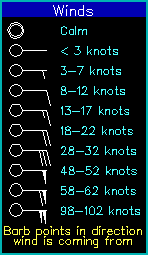
The winds are plotted as wind barbs with height (see below) on the right edge of the
plot.
The sounding also has height information plotted at the left, next to the pressure:
Specific sounding related parameters are plotted in the upper right. These values are:
|
Sounding diagrams provide a important means for determining the stability of the atmosphere above a specific location. By using the concept of an air parcel, lifting it or lowering it and comparing the resulting parcel conditions to the conditions of the surrounding environment as defined by the balloon sounding.
Parcels of unsaturated air tend to follow the dry adiabat lines (green lines) as they ascend or descend. The saturation adiabats (light blue) lines show how parcels saturated with water vapor will ascend or descend. Descending parcels will tend to unsaturate immediately. The mixing ratio lines (yellow) relate to the amount of water vapor in a parcel in grams of water vapor per kilograms of dry air. Parcels of air attempt to maintain a constant mixing ratio as they ascend or descend. Generally, a parcel will rise, following the dry adiabat until it saturates. This occurs when dry adiabat crosses the initial mixing ratio line. This is considered the LCL. If lifting continues, the parcel cools following the saturation adiabat. If the parcel descends, it will always follow the dry adiabat as it will immediately unsaturate if saturated. By then comparing the parcel temperature to the environment, you can determine whether it is stable (parcel cooler) or unstable (parcel warmer). An unstable parcel will accelerate upwards and is the primary means for thunderstorm development. A stable parcel will decelerate and eventually descend. This is the typical atmospheric condition and is the primary condition in high pressure areas. The descending air desaturates the atmosphere and leads to clearing skies and calm conditions.