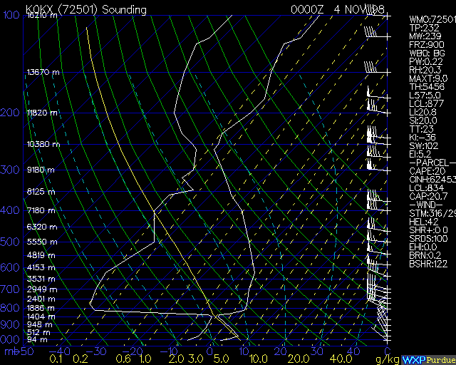
Make sure that you read the legend very carefully and understand the basic parts of the diagram. Then answer the questions below. You will most probably have to refer to the legend again when answering the questions.
1. What is the approximate surface elevation im meters?
2. What is the surface temperature and dew point?
3. What is the surface wind speed and wind direction?
4. What is the temperature at 400 mb?
5. At what elevation is the atmosphere most moist?
6. At what elevation is the atmosphere driest?
7. Why does the atmosphere warm with increasing height in the first 200 m?
8. At what elevation is the highest wind speed? What is the speed and direction at that elevation?
9. Where does the sounding curve follow the dry adiabatic lapse rate? (Your answer should be a range of elevation)
10. Where is the atmosphere stable? (Your answer should be a range of elevation)
11. Where is the atmosphere unstable? (Your answer should be a range of elevation)
12. Where (in millibars) is the lifted condensation level (based on surface data)?
13. If a parcel is lifted to the LCL (from #12) and the lifting mechanism ceases at that level, how much farther will the parcel ascend on its own?
14. Where (in millibars) would you find the tropopause?
15. Would you consider the atmosphere at this location to be mostly stable or mostly unstable? Why?