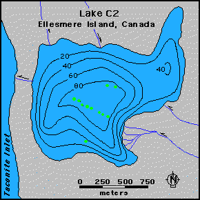
Map of Lake C2 showing the coring locations and the bathymetry of the lake.

Map of Lake C2 showing the coring locations and the bathymetry of the lake.
Green dots marks the transect of the short cores in Lake C2.
| Investigator(s): |
|
Sources of high resolution (i.e. annually resolved) paleoclimate information from the Arctic are currently limited to ice cores. However, annually laminated lake sediments provide another means of reconstructing past climatic variations in the Arctic. Lake C2, like most lakes at high latitudes, is frozen over for 9-10 months of the year and only receives runoff for a brief period in the summer. During this time, sediments are carried from the land and are deposited in the lake; during winter months no runoff occurs and the only sediments transferred to the lake floor are those fine particles left suspended in the lake waters when summer runoff came to an end. These slowly settle out, producing annual laminations (varves) each of which are made up of both coarse and fine sub-layers. Sediment cores retrieved from lake C2 thus contain a record of laminae (analogous to the annual growth increments of trees) which record conditions in the lake watershed year-by-year.
A set of cores along a transect from the main inlet stream to the lake outlet (figure above).
Detailed studies of short cores along this transect were studied by B. Zolitschka to understand the sediment depositional pattern from proximal to distal locations, with respect to the main delta. In addition, long cores (~2.4m) were recovered from the deep (>80m) basin in the lake. Work on these sediments is currently in progress.