The Bedrock Geologic Map of Massachusetts
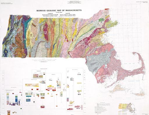
The 1:250,000 scale Bedrock Geologic Map of Massachusetts, published by the USGS in 1983, shows the distribution of the different rock units, faults, and other features that make up the bedrock of Massachusetts. It was compiled from published 1:24,000-scale maps., unpublished data, and field reconnaisance by the authors. Many areas of the state, however, have yet to be mapped thoroughly at 1:24,000 scale.
-
A paper copy of the map can be obtained from the Earth Science Information Office at the University of Massachusetts for $17.
- NEW!
A digital
database of the map, that can be downloaded in a variety of
formats, is available from
the USGS here.
-
A GIS version of the map can be obtained by MassGIS.
-
NEW! A scanned version of this map is available in ESRI MrSID format from the USGS here.
-
A two-volume text, The Bedrock Geology of Massachusetts, published in 1991, accompanies the map and can be purchased through the Earth Science Information Office at U-Mass, Amherst, or through the USGS by calling 1-888-ASK-USGS. The publication is catalogued as U.S. Geological Survey Professional Paper 1366 A-D (western Mass.) and 1366 E-J (eastern Mass.)
- An alternative interpretation of the geology of the eastern part of the state is portrayed in USGS Open File Report 77-285: Preliminary compilation of the bedrock geology of the land area of the Boston 2 degree sheet, Massachusetts, Connecticut, Rhode Island and New Hampshire.
Questions / Comments / Problems with our website? Please let us know: jkopera@geo.umass.edu
webpage last updated 7/2006