(here's the 1995 Version)
In response to a query that originally appeared on the Mountain Forum list, asking what percent of the earth's surface and human population exist above 4000 feet (1220 meters) elevation, I first created a GIS-based answer using 1995 data.
Recently I was contacted with a request to include populations above 7000 feet, and I used the opportunity to get the latest population and terrain data. For the results shown below, I used digital elevation data from SRTM30 sub- averaged to 2.5 x 2.5 minute cell size to match the resolution of the gridded, UN-adjusted population data for the year 2000 from GPWv3. Putting those data into the GIS again yielded the following updated numbers:
| Global | Above 4000' | 4000-7000' | Above 7000' | |
| Land Area (1000 km2) | 148,875 | 29,844 (20.0%) | 15,370 (10.3%) | 14,474 (9.7%) |
| Population (1000s) | 6,056,471 | 618,971 (10.2%) | 434,392 (7.2%) | 184,580 (3.0%) |
| Density (people/km2) | 40.7 | 20.7 | 28.3 | 12.8 |
A minor challenge this time around was incorporating Antarctica in the terrain data; that region is included in the older GTOPO30 dataset but not the version of the SRTM30 data I downloaded (I have seen some hybrid versions but I haven't downloaded them to play with). I realized in the process of working with the Antarctic data (from GTOPO30) that it comprises one-third of all land areas above 4000', but has zero population (excepting a few hardy souls at the polar stations). Greenland also includes a large, elevated, uninhabited region. If either or both of these land areas were taken out of the analysis, the numbers in the table above would be quite different.
As before, there is an extensive list of publications using the GPW data, including a followup analysis of terrain and population by the Small & Cohen team, this time switching the lead.
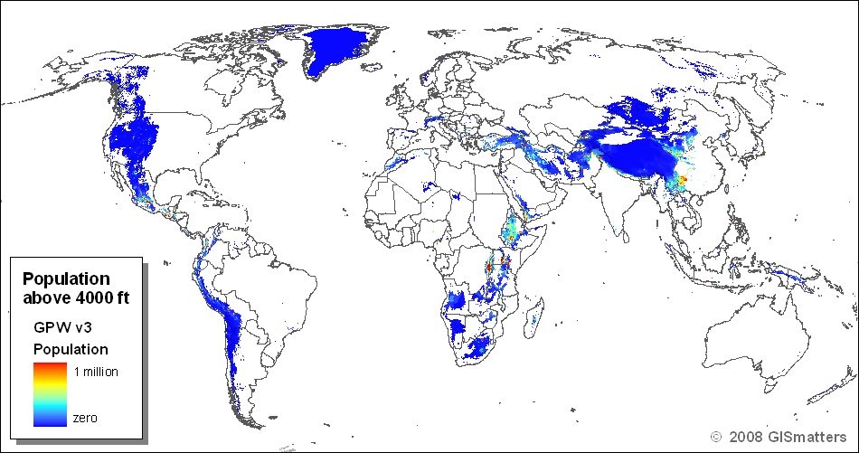
This image shows the regions where elevation is 4000 feet or above, with the color indicating the GPWv3 population present in each cell:
Last updated 09-Jul-2008