This page links to an informal collection of (mostly) images used to plan the 1999, 2000, and 2002 expeditions to Bhutan, and to communicate information, ideas, and results among the group members. If any of this material is useful to you, you're welcome to use it so long as you credit Chris Duncan and notify me of your usage. If you think I may be able to provide you with related material to assist in your own research or other activities, please contact me at duncan@geo.umass.edu.
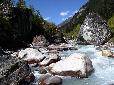 Photos from the 2002 expedition
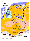
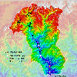 Routes and sample sites
for 1999 and 2000 expeditions
Routes and sample sites
for 1999 and 2000 expeditions
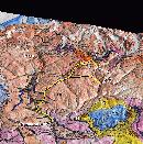 3-D Routes and sample sites
for 2002 expedition
3-D Routes and sample sites
for 2002 expedition
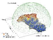 GIS-based cosmogenic
isotope production rate calculations
GIS-based cosmogenic
isotope production rate calculations
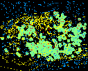 Candidate landslide
locations based on fluvial geomorph features
Candidate landslide
locations based on fluvial geomorph features
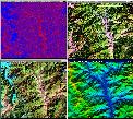 Change
detection experiments with satellite imagery
Change
detection experiments with satellite imagery
 Fission-track
figures for AGU Fall 2002 meeting
Fission-track
figures for AGU Fall 2002 meeting
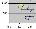
 Figures analyzing cosmogenic-based
erosion estimates for Wangduephodrang watershed
Figures analyzing cosmogenic-based
erosion estimates for Wangduephodrang watershed
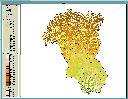
 Sample
site maps and watershed statistics charts
Sample
site maps and watershed statistics charts
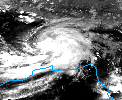 Satellite images of
a rainstorm that kept us grounded in Paro for 2 days in 1999
Satellite images of
a rainstorm that kept us grounded in Paro for 2 days in 1999
 Images
of things I made in Bhutan in 1999, inspirited by Andy
Goldsworthy, among others.
Images
of things I made in Bhutan in 1999, inspirited by Andy
Goldsworthy, among others.